Who launched the INSAT 3D satellite and when
Categories: Technology
The launch of the INSAT-3DS satellite was originally scheduled for January 2024, however it was eventually moved to February. The satellite was launched on February 17, 2024, at 17:35 IST (12:05 UTC), using the GSLV-F14 rocket.
On Saturday, February 17, 2024, at 17:30 hours IST, the GSLV-F14/INSAT-3DS mission is successfully launched from SDSC-SHAR in Sriharikota. The INSAT-3DS meteorological satellite is to be launched into the Geosynchronous Transfer Orbit (GTO) by the GSLV on its sixteenth mission. Later orbit-raising operations will guarantee that the satellite is in a geostationary orbit.
GSLV-F14
The three-stage, 51.7-meter-long Geosynchronous Satellite Launch Vehicle (GSLV) has a liftoff mass of 420 tonnes. A solid propellant (S139) motor with 139 tons of propellant and four earth-storable propellant stages (L40) strapons, each holding 40 tons of liquid propellant, make up the first stage (GS1). With 40 tons of propellant in it, the second stage (GS2) is likewise an earth-storable propellant stage. Liquid oxygen (LOX) and liquid hydrogen (LH2) make up the 15-ton propellant loading of the cryogenic third stage (GS3). Ogive payload fairing shields the satellite during the atmospheric regime. A wide range of spacecraft with the ability to conduct communications, navigation, earth resource surveys, and other proprietary missions can be launched using GSLV.
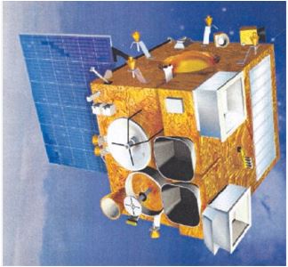
INSAT-3DS
A successor to the Third Generation Meteorological Satellite from Geostationary Orbit is the INSAT-3DS Satellite. Ministry of Earth Sciences (MoES) provides full funding for the GSLV-F14/INSAT-3DS mission. It is intended to improve meteorological observations and surface monitoring for weather forecasting and hazard alerts on land and in the ocean. The satellite, in addition to the currently in operation INSAT-3D and INSAT-3DR satellites, will enhance the Meteorological services. Indian industries have made a substantial contribution to the satellite's construction.
The INSAT-3DS Satellite data will be used by several departments of the Ministry of Earth Sciences (MoES) to provide better weather forecasts and meteorological services, including the India Meteorology Department (IMD), National Centre for Medium-Range Weather Forecasting (NCMRWF), Indian Institute of Tropical Meteorology (IITM), National Institute of Ocean Technology (NIOT), Indian National Center for Ocean Information Services (INCOIS), and numerous other agencies and institutes.
Our perception and relationship with our world have been completely transformed by satellites. The Indian National Satellite System (INSAT) is one of the many satellites in orbit above Earth that has played a major role in supplying vital meteorological, telecommunication, and broadcasting data. One of its prominent members is the INSAT-3D satellite, which is essential to tracking and comprehending a range of atmospheric events. This article explores the main goals of the INSAT-3D satellite and how important it is to further our knowledge of Earth's atmosphere.
The Primary Objectives of the INSAT-3D Satellite
Prior to exploring its goals, let's get a fundamental understanding of INSAT-3D. The sophisticated meteorological satellite INSAT-3D was created to monitor and record meteorological occurrences in the Indian Ocean Region (IOR). With its orbital slot at 82° East longitude, it is a vital instrument for climate and meteorological research, helping to forecast weather patterns and natural disasters.
a. Monitoring Weather Patterns
High precision and accuracy weather pattern monitoring is one of INSAT-3D's main goals. The satellite, which is outfitted with sophisticated sensors and imaging powers, monitors a number of climatic variables on a constant basis, including temperature, humidity, cloud cover, and atmospheric motion. Meteorologists can study weather trends, forecast changes, and send out timely alerts for approaching natural disasters like cyclones, hurricanes, and heavy rains by collecting real-time data on these variables.
b. Enhancing Weather Forecasting
Improving INSAT-3D's capacity for weather forecasting is another important goal. The satellite's geostationary orbit enables it to continuously and unbrokenly observe the surrounding maritime regions as well as the Indian subcontinent. Meteorologists can create precise numerical weather prediction models because to this ongoing observation, which raises the precision and dependability of weather forecasts. A variety of industries, including agriculture, aviation, and disaster management, can benefit from forecasters' ability to produce accurate and fast localized weather forecasts by combining INSAT-3D data with other satellite and ground-based observation data.
c. Monitoring Atmospheric Parameters
INSAT-3D seeks to observe and analyze a variety of atmospheric factors crucial to comprehending climate dynamics in addition to tracking weather patterns. These variables include the concentration of ozone, the distribution of water vapor, sea surface temperature, and atmospheric temperature profiles. Through the long-term monitoring of these indicators, scientists may evaluate the effects of climate change, investigate long-term trends in climate, and create mitigation plans to deal with environmental issues.
d. Studying Atmospheric Dynamics
The study of atmospheric dynamics and processes that affect weather and climate greatly benefits from the use of INSAT-3D. Its cutting-edge instruments shed important light on processes like precipitation patterns, cloud formation, and atmospheric convection. Scientists can gain a better grasp of intricate atmospheric phenomena and their consequences for local and global climate systems by tracking these processes in real time. Accurately creating climate models and forecasting future climatic scenarios require this knowledge.
e. Supporting Disaster Management
One important instrument for disaster management and mitigation is the INSAT-3D satellite. Authorities are able to provide timely warnings and carry out preparatory measures because of its real-time detection of natural disasters and ability to monitor weather patterns. In order to enable efficient reaction and relief efforts during natural disasters including cyclones, floods, and droughts, INSAT-3D offers vital information on the location, severity, and movement of the disaster. Decision-makers can lessen the toll that natural catastrophes have on infrastructure and human lives by utilizing satellite data.
f. Facilitating Telecommunication and Broadcasting
In addition to its meteorological goals, INSAT-3D serves the Indian subcontinent's broadcast and telecommunication needs. Its transponders enable connectivity to remote and rural locations by facilitating the transmission of radio, television, and telecommunications signals. The communication capabilities of INSAT-3D are also used for emergency response and disaster communication, allowing authorities to coordinate relief efforts and educate impacted people.
Our knowledge of Earth's atmosphere and our capacity to track and forecast weather patterns have greatly improved thanks to the INSAT-3D satellite. Meteorology, climate science, and disaster management are among the fields that benefit from its main goals, which include monitoring weather patterns, improving weather forecasting, researching atmospheric characteristics, and providing help for disaster management. By leveraging the capabilities of satellites such as INSAT-3D, we are getting closer to creating a future that is more sustainable and resilient to environmental shocks.